1875 Carta General del Archipiélago Filipino: The Map That China Doesn't Want You To See
A 150-year-old Spanish map is sitting at the center of one of the most consequential territorial disputes in Asia — and most Filipinos have never heard of it. This is a deep dive into the 1875 Carta General del Archipiélago Filipino: what it is, how it survived two empires and a world war, and why it legally dismantles China's nine-dash line claim over the West Philippine Sea. Retired Supreme Court Justice Antonio Carpio spent seven years finding a copy. It took me a few days to understand why that matters.
11 min read
China declared Scarborough Shoal a national nature reserve in September 2025.
A nature reserve. For a shoal that isn't theirs.
A few days ago I read a piece about retired Supreme Court Senior Associate Justice Antonio Carpio and his years-long effort to resurface a 150-year-old Spanish map — one that, according to him, legally dismantles everything China is claiming in the West Philippine Sea. I had never heard of this map. I had never heard it discussed in school, in the news, in any political conversation I can remember.
So I looked into it. To learn. To understand.
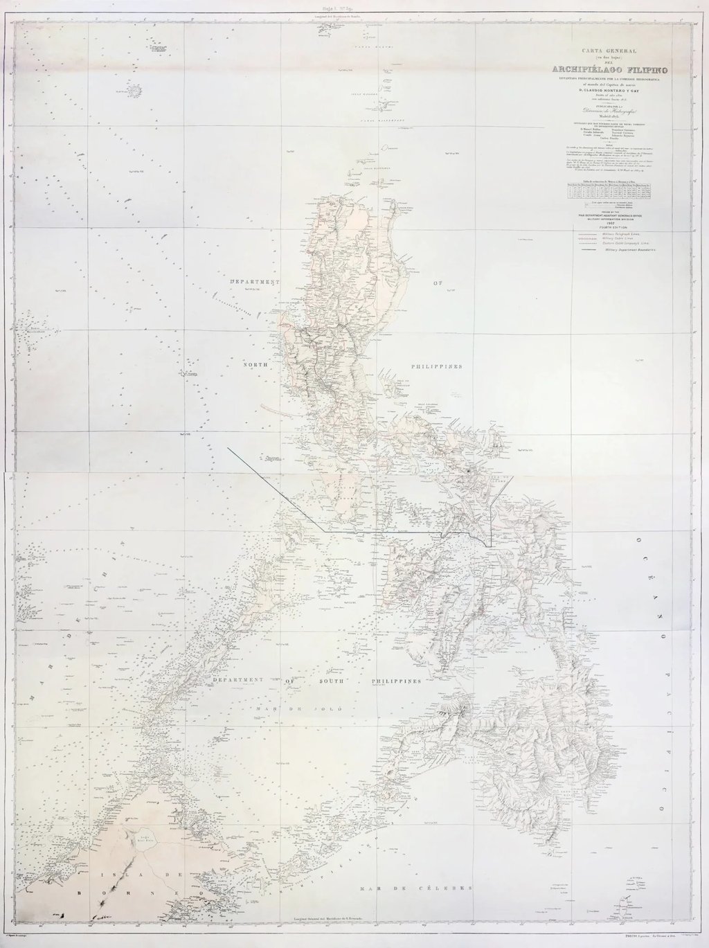
The map is the 1875 Carta General del Archipiélago Filipino. Hand-engraved, stamped with royal authority, drawn to a scale of 1:321,200 with depth soundings and coastlines and the names of every significant maritime feature in the Philippine archipelago — including, right there, a shoal labeled "B. Masingloc o Scarborough."
That map has been adopted by the U.S. military, submitted to an international court, used as the geographic backbone of a census, and formally recognized as both a Spanish and an American official state document. It predates the nine-dash line by 72 years.
And for decades, most Filipinos had no idea it existed.
Once you see what this map is and what it's been through, China's September 2025 declaration doesn't look like a conservation effort. It looks like a country trying to win on the ground what it already lost in court.
WHAT IS THIS MAP
The 1875 Carta General del Archipiélago Filipino was not a sketch. It was a formal instrument of imperial governance.
The Spanish Hydrographic Commission began its surveys in 1859 under Navy Lieutenant Claudio Montero y Gay. Field surveys were largely completed by 1870. The final map was published in Madrid in 1875 by the Dirección de Hidrografía — Spain's official charting office. The map was stamped with the royal insignia of King Alfonso XII of Spain.
The physical document spans roughly 91 by 68 centimeters, drawn to a scale of 1:321,200, printed on material often mounted on canvas. It contains depth soundings, coastlines, bays, straits, and mountain topographies across the entire archipelago.
Most importantly: it explicitly marks "B. Masingloc o Scarborough" — Scarborough Shoal — and includes the reef systems of the Spratly Islands. Not as disputed territory. Not as contested waters. Just there. Surveyed, named, incorporated.
Governments don't commission precision naval charts of someone else's territory.
300 YEARS OF THE SAME ANSWER
The 1875 map wasn't a one-time assertion. It was the latest entry in a lineage that stretches back three centuries.
In 1734, a Jesuit priest named Pedro Murillo Velarde — assisted by Filipino illustrator Francisco Suarez and engraver Nicolas de la Cruz Bagay — published what historians call the "mother of all Philippine maps." It identified three reef structures on the western approaches to Manila with indigenous Tagalog names: Galit (anger), Lumbay (sorrow), and Panacot — meaning danger or threat. Panacot is Scarborough Shoal.
Filipino mariners named it for what it did to ships.
After Murillo Velarde, the cartographic record kept building. London cartographers Robert Laurie and James Whittle included Scarborough Shoal in 1802. Spain's Dirección de Hidrografía reaffirmed it in 1808, incorporating the 1792 survey by Spanish explorer Alejandro Malaspina who had physically gone there after a British tea clipper called the Scarborough ran aground on those rocks in 1748. The 1875 Carta General followed. Then the 1897 Carta General del Océano Pacífico.
Nobody was fighting over these features in those centuries. Everyone just kept drawing them as part of the Philippines.
Three hundred years of consistent, uncontested cartographic documentation. In international law, that consistency is not a footnote. It is the argument.
THE TREATY DISASTER AND THE $100,000 FIX
When the United States defeated Spain in 1898, the two countries signed the Treaty of Paris, which formally ceded the Philippine archipelago to the United States. The problem: the geometric lines drawn into that treaty were wrong. The coordinates failed to match the geographic realities of the region and accidentally left out Scarborough Shoal, parts of the Spratly Islands, and peripheral territories like Cagayan de Sulu and Sibutu.
The Americans noticed quickly. Their corrective move was decisive: the U.S. War Department officially discarded the flawed Treaty of Paris map and formally adopted the 1875 Carta General del Archipiélago Filipino as the definitive cartographic authority over their new Pacific territory.
They didn't just copy it. They built on it. Military cartographers added overlays of telegraph networks, submarine cable lines, and the boundaries of newly established military departments. The map was reissued in four official U.S. editions — in 1899, 1900, 1901, and 1902. A Spanish imperial document became a joint Spanish-American state instrument.
The integration ran deeper than the military. When the American civil government built the 1903 Census of the Philippine Islands — the most exhaustive demographic and geographic survey of the archipelago to that point — it used the 1875 map's data as its geographic baseline. Leading Filipino intellectual T.H. Pardo de Tavera contributed a full historical review to the census, cementing administrative continuity between the two colonial regimes. The map wasn't just a war tool. It was how the government counted its own people.
To fix the treaty language on paper, the United States and Spain negotiated the Treaty of Washington, signed November 7, 1900. Spain formally relinquished to the United States "all title and claim of title" to "any and all islands belonging to the Philippine Archipelago, lying outside the lines described" in the 1898 treaty. The U.S. paid Spain $100,000 for that clarification.
In 1938, Secretary of State Cordell Hull issued a formal internal memorandum determining that Scarborough Shoal "should be regarded as included among the islands ceded to the United States" by the 1900 Treaty of Washington.
America paid extra money specifically to include these features. Then it ran its census off the same map. That is about as unambiguous as sovereign intent gets.
THE COURTROOM TEST
The map wasn't just used for administration. It was tested in an international court — and it held.
In 1928, a territorial dispute over a small island called Palmas (or Miangas) between the United States and the Netherlands went to the Permanent Court of Arbitration at The Hague. The U.S. submitted the 1875 Carta General as a primary evidentiary document and formally declared to the tribunal that it was "both an American official and a Spanish official map" of Philippine territory.
That declaration mattered beyond the case itself. By vouching for the map before an international tribunal, the United States bound itself — and by succession, the Republic of the Philippines — to recognizing all territories delineated therein as sovereign parts of the archipelago.
Swiss arbitrator Max Huber's ruling established a principle that still governs territorial disputes today: discovery alone does not give you a territory. What matters is "continuous and peaceful display of territorial sovereignty." Planting a flag somewhere in the 16th century gives you an incomplete title. Maintaining administrative presence, conducting surveys, issuing official maps, incorporating those features into treaties and census data — that is what perfects a claim.
The 1875 map was exactly that display. A century of state use across two empires. The map passed the test that international law actually uses. Not sentiment. Not history lessons. A binding legal proceeding.
CHINA'S MAPS SAY SOMETHING DIFFERENT
China's claim to the West Philippine Sea rests on the nine-dash line — a sweeping enclosure that covers approximately 80% of the Philippines' Exclusive Economic Zone, along with vast portions of Vietnam's, Malaysia's, Brunei's, and Indonesia's EEZs. The line first appeared as an 11-dash line in a 1947 map produced by the nationalist Republic of China. Two dashes were removed from the Gulf of Tonkin in 1953 with no official explanation, leaving nine. China didn't officially announce the nine-dash line to the international community until 2009, when it attached a map to a UN Note Verbale — with no geographic coordinates and no legal basis cited under UNCLOS.
But the more damaging evidence comes from China's own archives.
A review of ancient Chinese maps from the Song Dynasty through the late Qing consistently places Hainan Island as China's absolute southernmost territory. Every single one. The Hua Yi Tu, engraved in stone in 1136: Hainan is the southern limit. The Da Ming Hun Yi Tu, painted on silk in 1389: same boundary. Qing Dynasty maps spanning 1814 to 1885 — including the Qing Wan Nian Yi Tong Di Li Quan Tu, the Guangdong Tong Sheng Shui Dao Tu, the Guangdong Quan Tu, and the Da Qing Er Shi San Sheng Yu Di Quan Tu — all draw the same line. Hainan. Not the Spratlys. Not Scarborough.
Then there's the 1943 China Handbook — an official Chinese government publication issued during World War II — which explicitly defined China's southernmost territory as Triton Island in the Paracels. The Spratlys aren't mentioned. Scarborough isn't mentioned.
Under international law, this triggers estoppel: you cannot make an official sovereign declaration to the world and then contradict it when the same territory becomes economically or strategically valuable. China's own government told the world, as recently as 1943, that its territory did not extend to these features.
The receipts are sitting in Beijing's own archives.
THE MAN WHO FOUND THE MAP
For all its legal weight, the 1875 Carta General spent decades outside public consciousness.
Part of this was the chaos of transition — from Spanish colonial rule to American administration to independence. Part of it was deliberate. When Imperial Japan claimed the Spratly Islands in 1939 before the Pacific War, it had a direct strategic interest in the erasure of documents placing those features under Philippine jurisdiction. The destruction of archives and libraries during the Japanese occupation accomplished exactly that. Original Philippine government copies of the map were lost.
For decades after independence, many Philippine school maps passively incorporated China's dashed lines, or simply excluded the disputed territories to avoid friction. Generations of Filipinos grew up without knowing the map existed.
The resurrection of the Carta General into public life is largely the work of retired Supreme Court Senior Associate Justice Antonio Carpio. He spent seven years traveling to Madrid and parts of the United States looking for a surviving copy. He eventually found one through a private collector he met at an exhibit in Cebu. He bought it. That copy — described as likely the only one currently in the country — is what he donated to the National Library of the Philippines on March 19, 2026.
His central axiom: "A state with strong title submits to arbitration. One with weak title runs away from arbitration."
The public campaign didn't stop at institutional donations. The National Historical Commission, the National Library, and academic partners launched a traveling exhibition called "Pag-asa sa Gitna ng Kalayaan" — Hope Amidst Freedom — to bring this history directly to ordinary Filipinos. The exhibition features the 1875 Carta General alongside the 1734 Murillo Velarde map, presented together as the documentary pillars of the Philippines' Hague victory. It also displays the original flag of Tomas Cloma's "Free Territory of Freedomland" — the Filipino fisherman and entrepreneur who, in 1956, led 40 men to formally claim the Spratly Islands decades before they were integrated into Palawan as the Kalayaan Island Group. Documentary photographs by Paul Quiambao capture daily life on Pag-asa Island — the schools, the families, the livelihoods. A miniature model of the BRP Sierra Madre, the deliberately grounded naval vessel that serves as a military outpost at Ayungin Shoal, sits among these artifacts.
Ito yung tipong story na hindi ka makapaniwala na totoo. A retired judge. Seven years of searching across two countries. A private collector in Cebu. A map that shifted the legal posture of an entire country. And an exhibit that finally put it in front of the people who needed to see it.
WHAT THE 2016 RULING CONFIRMED — AND WHY IT'S BEING IGNORED
On July 12, 2016, the UNCLOS Arbitral Tribunal at The Hague ruled in favor of the Philippines. The tribunal was unambiguous: China's historic rights claims over maritime areas within the nine-dash line "have no lawful effect" to the extent they exceed what is permitted under the Convention.
The underlying principle is one Carpio has repeated consistently in his lectures: historical names do not generate sovereign maritime zones. India cannot own the Indian Ocean. Mexico cannot own the Gulf of Mexico. China cannot own the South China Sea because its ancestors sailed through it.
What the 1875 Carta General establishes is the Philippines' historic title over the land features — the shoals and islands themselves. UNCLOS then determines the maritime zones extending from those features. The two together dismantle the nine-dash line from both directions: documented title over the features on one side, and international law forbidding sweeping maritime enclosure on the other.
China has not complied with the ruling. Beijing doesn't recognize it.
On September 10, 2025, China's State Council approved the creation of the "Huangyan Island National Nature Reserve" at Scarborough Shoal — covering 3,523 hectares, with a core zone where all human activity is prohibited and an experimental zone allowing limited access. Under China's domestic regulations, the announcement immediately gave the Chinese coast guard legal domestic cover to expel Philippine fishing and government vessels from waters within the Philippines' own EEZ.
The international response was swift. The United States, under Secretary of State Marco Rubio, called it "yet another coercive attempt to advance sweeping territorial and maritime claims in the South China Sea at the expense of its neighbors." Australia urged respect for UNCLOS and the 2016 ruling. Japan's ambassador said he was "seriously concerned" that the unilateral action "could undermine regional stability." Canada said it opposes attempts "to use environmental protection as a way to take control over disputed territory." Denmark and the European Union also voiced concern.
Under international law, actions taken after the critical date — 1947, when the Republic of China first published its dashed-line map — carry no legal weight in determining sovereignty. The nature reserve declaration is legally null.
But it is physically real. The coast guard is there. The barriers are there.
THE HARD QUESTION
I came into this knowing nothing about maritime law. I leave it knowing that a 150-year-old Spanish map — commissioned by a colonial government, adopted by an American military, used to count Filipino people in a census, submitted to an international tribunal, and formally declared an official state document of two empires — is a stronger legal instrument than anything China has produced in support of its claims.
The cartographic lineage is unbroken. The legal tests have been run and passed. The 2016 ruling exists. The receipts, including China's own, are on the table.
But documents don't hold water. Ships do.
The Philippines filed a diplomatic protest. Australia, Canada, Japan, the U.S., and the EU issued statements. The international community called it illegal. China kept the nature reserve. The BRP Sierra Madre is still rusting at Ayungin Shoal.
What good is the strongest legal title in the room if enforcement is always someone else's problem?
SOURCES:
Al Jazeera — US condemns Beijing's South China Sea 'nature reserve' plan, September 2025 — https://www.aljazeera.com/news/2025/9/13/us-condemns-beijings-south-china-sea-nature-reserve-plan
GMA News — Australia, Canada, Japan nix China nature reserve plan in Scarborough Shoal — https://www.gmanetwork.com/news/topstories/nation/959192/australia-canada-japan-nix-china-nature-reserve-plan-in-scarborough-sho
Philstar — More nations air concern vs China's Scarborough nature reserve, September 2025 — https://www.philstar.com/headlines/2025/09/15/2472981/more-nations-air-concern-vs-chinas-scarborough-nature-reserve
The Diplomat — China's Nature Reserve at Scarborough Shoal Isn't Just About Conservation, November 2025 — https://thediplomat.com/2025/11/chinas-nature-reserve-at-scarborough-shoal-isnt-just-about-conservation/
CNN — Why is China setting up a nature reserve in the South China Sea, September 2025 — https://www.cnn.com/2025/09/11/asia/china-nature-reserve-south-china-sea-intl-hnk
Reuters — What is the Scarborough Shoal and what is China planning there, September 2025 — https://www.reuters.com/business/aerospace-defense/what-is-scarborough-shoal-what-is-china-planning-there-2025-09-11/
Japan Times — US rejects China nature reserve plan in South China Sea, September 2025 — https://www.japantimes.co.jp/news/2025/09/13/asia-pacific/us-china-scarborough-shoal-nature-reserve/
Vera Files — PH wins: Arbitral court invalidates China's 9-dash line, July 2016 — https://verafiles.org/articles/ph-wins-u-n-arbitral-court-invalidates-chinas-9-dash-line
Wikipedia — South China Sea Arbitration — https://en.wikipedia.org/wiki/South_China_Sea_Arbitration
Wikipedia — Island of Palmas Case — https://en.wikipedia.org/wiki/Island_of_Palmas_Case
Permanent Court of Arbitration — Island of Palmas Case (Netherlands v. USA), 1928 — https://legal.un.org/riaa/cases/vol_ii/829-871.pdf
Wikipedia — Free Territory of Freedomland — https://en.wikipedia.org/wiki/Free_Territory_of_Freedomland
Kalayaan Palawan Official Website — History of Kalayaan — https://www.kalayaanpalawan.gov.ph/about.html
Defacto Borders — The Conquest of Tomás Cloma — https://www.defactoborders.org/places/spratly-islands/freedom-for-tomas-cloma
Inquirer Opinion — The old man and the sea (Tomas Cloma), June 2015 — https://opinion.inquirer.net/86123/the-old-man-and-the-sea
Think China — Scarborough Shoal: Is China's nature reserve a military outpost in disguise, September 2025 — https://www.thinkchina.sg/politics/scarborough-shoal-chinas-nature-reserve-military-outpost-disguise
YouTube — Justice Carpio delivers lecture on islands in West Philippine Sea — https://www.youtube.com/watch?v=Vs3nubSqb5c
YouTube — Ceremonial Turnover of the 1875 Carta General, National Library of the Philippines, March 2026 — https://www.youtube.com/watch?v=yc27fw3pOBc
YouTube — Carpio counters China's historical claims with 1734 and 1875 maps — https://www.youtube.com/watch?v=Wl6Lb1Eo3fI
Abogado PH — Retired SC Justice Carpio donates 1875 map to National Library — https://abogado.com.ph/ex-sc-justice-carpio-donates-1875-map-of-ph-territory-to-the-national-library/
Philippine Information Agency — Elusive 1875 PH map found, ending Carpio's years-long search — https://pia.gov.ph/news/elusive-1875-ph-map-found-ending-carpios-years-long-search/
Inquirer — Carpio: 'Forgotten' 1875 map backs PH vs China sea claim — https://www.inquirer.net/470796/forgotten-1875-map-backs-ph-vs-china-sea-claim-carpio/
Philstar — Carpio: 1875 map proves Philippines claims to West Philippine Sea — https://www.philstar.com/headlines/2026/03/22/2516008/carpio-1875-map-proves-philippines-claims-west-philippine-sea
BusinessWorld — The 1875 Carta General del Archipielago Filipino — https://www.bworldonline.com/opinion/2026/03/23/737892/the-1875-carta-general-del-archipielago-filipino/
Tribune — Historic map sheds light on Philippines' maritime heritage — https://tribune.net.ph/2026/03/22/historic-map-sheds-light-on-philippines-maritime-heritage
One News PH — Carpio: 1875 Map Proves Philippines' Claims To WPS — https://www.onenews.ph/carpio-1875-map-proves-philippines-claims-to-wps
Philippine Information Agency — 1875 Carta General del Archipelago Filipino map to guide PH sovereignty in Scarborough Shoal, KIG — https://pia.gov.ph/news/1875-carta-general-del-archipelago-filipino-map-to-guide-ph-sovereignty-in-scarborough-shoal-kig/
Silliman University — SC Justice Carpio on Maritime Dispute with China: We Need the World Behind Us — https://su.edu.ph/2007-sc-justice-carpio-on-maritime-dispute-with-china-we-need-the-world-behind-us/
DFA MANA Mo — 1875 Carta General del Archipielago Filipino — https://sites.google.com/dfa.gov.ph/manamo/other-resources/1875-carta-general-del-archipielago-filipino
Asian Century PH — Scarborough Nature Reserve: AI not intelligent after all — https://asiancenturyph.com/2026/02/08/scarborough-nature-reserve-ai-not-intelligent-after-all/
Contact us
subscribe to morning coffee thoughts today!
inquiry@morningcoffeethoughts.org
© 2024. All rights reserved.
If Morning Coffee Thoughts adds value to your day, you can support it with a monthly subscription.
You can also send your donation via Gcash: 0969 314 4839.